Illustrated Map For the Fort Lauderdale International Boat Show
Client: Informa Markets
For information about the Fort Lauderdale International Boat Show visit FLIBS.com
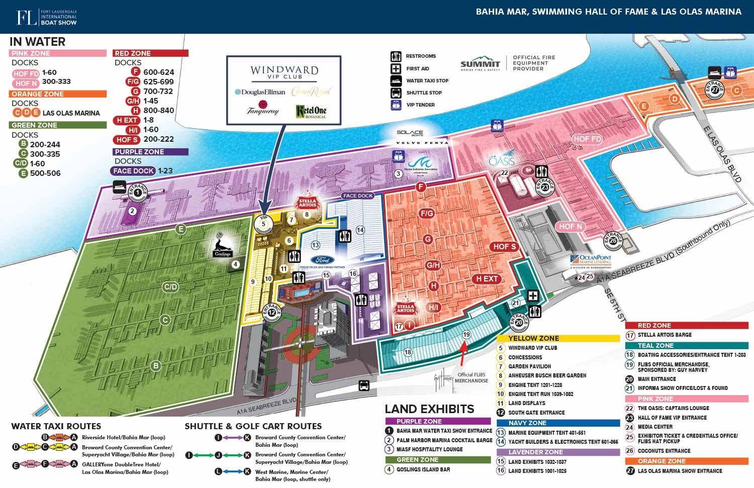
For the 2023 Fort Lauderdale International Boat Show, I continued my long standing role updating the illustrated site map covering Bahia Mar, Las Olas Marina, and the International Swimming Hall of Fame. This map plays a central role in helping thousands of attendees navigate one of the largest in water boat shows in the world. Each year requires careful revisions to reflect the evolving layout of the show, and the 2023 edition involved extensive updates to dock configurations, exhibitor areas, hospitality tents, and access points. Sponsor logos were reviewed and adjusted to ensure accurate placement and clear visibility throughout the map.
This was the first year of including graphical menus indicating Water Taxi, shuttle and golfcart routes. These were a standardized feature across all maps in the program making it easier to understand how to move from venue to venue utilizing the supplied, dedicated transit system.
The map preserves the Fort Lauderdale International Boat Show’s established color zone system, which is essential for managing an event of this scale. Color coding allows visitors to quickly orient themselves by identifying broad areas of interest before narrowing their focus to individual docks or exhibitor sections. This layered approach to navigation improves usability for first time attendees while remaining intuitive for experienced show goers, exhibitors, and staff.
To maintain clarity and readability, the illustration emphasizes the official show footprint rather than surrounding city details. Docks are labeled with lettered identifiers, land based features are keyed numerically, and shared amenities such as restrooms, services, and transportation points are represented with clear icons. These design decisions ensure the map functions effectively across multiple formats, including printed show guides, large format signage, mobile devices, and digital platforms. This project highlights the value of custom illustrated maps as both practical wayfinding tools and strong visual assets for large scale marine events.
Fort Lauderdale International Boat Show Maps 2023:
Bahia Mar, Swimming Hall of Fame & Las Olas Marina | Transit and Parking | Marinas (17th St Cswy) | Broward County Convention Center Map | Program LayoutFort Lauderdale International Boat Show Maps:
- About Fort Lauderdale International Boat Show
- Bahia Mar, Swimming Hall of Fame & Las Olas Marina Maps: 2025 | 2024 | 2023 | 2022 | 2020 | 2019 | 2018 | 2017 | 2016 | 2015 | 2014 | 2013 | 2012 | 2011 | 2010
- Parking and Transportation Maps: 2025 | 2024 | 2023 | 2022 | 2020 | 2019 | 2018 | 2015 Bus | 2015 Water Taxi | 2014 | 2013 | 2012 | 2011
- Broward County Convention Center Maps: 2025 | 2024 | 2023 | 2022 | 2017 Sailfish Pavilion | 2017 | 2016 Sailfish Pavilion | 2016 | 2015 Sailfish Pavilion | 2015 | 2014 Sailfish Pavilion | 2014 | 2013 Sailfish Pavilion | 2013 | 2012 | 2011 | 2010
- Marinas Maps: 2025 | 2024 | 2023 | 2022 | 2019 | 2016
- Program Layouts: 2025 | 2024 | 2023 | 2022
- Signs: 2013 looking north | 2013 Yachting Tent
- Video: 2013 54th Annual
- Illustrations (not maps): 2014A | 2014B
PORTFOLIOS
- Illustration Portfolio: Start here for custom illustration and book covers. You can also browse illustrated maps and architectural rendering.
- Fine Art: I offer original paintings and drawings, including my Custom Halftone Series. You will also find mural work here.
- Graphic Design & Motion: View my graphic design portfolio. After that, explore motion design and animated illustrations.
- Maps by application: I create illustrated maps for boat shows, resorts, marinas, real estate, transportation, transit and parking, towns and cities, parks, and wayfinding.
- Additional project types: I also produce cover illustration, vehicle and vinyl wraps, proposal renderings, and street art.
- Illustration methods: My techniques include vector, isometric and axonometric, painting, black and white, GeoData maps, overhead maps, and custom halftones.
- Software portfolios: I work primarily in Adobe Photoshop, Adobe Illustrator, SketchUp Pro, and Adobe InDesign. For motion projects, I use Premiere Pro and After Effects.