3D rendering of a map used for guests to the boat show
Client: Show Management
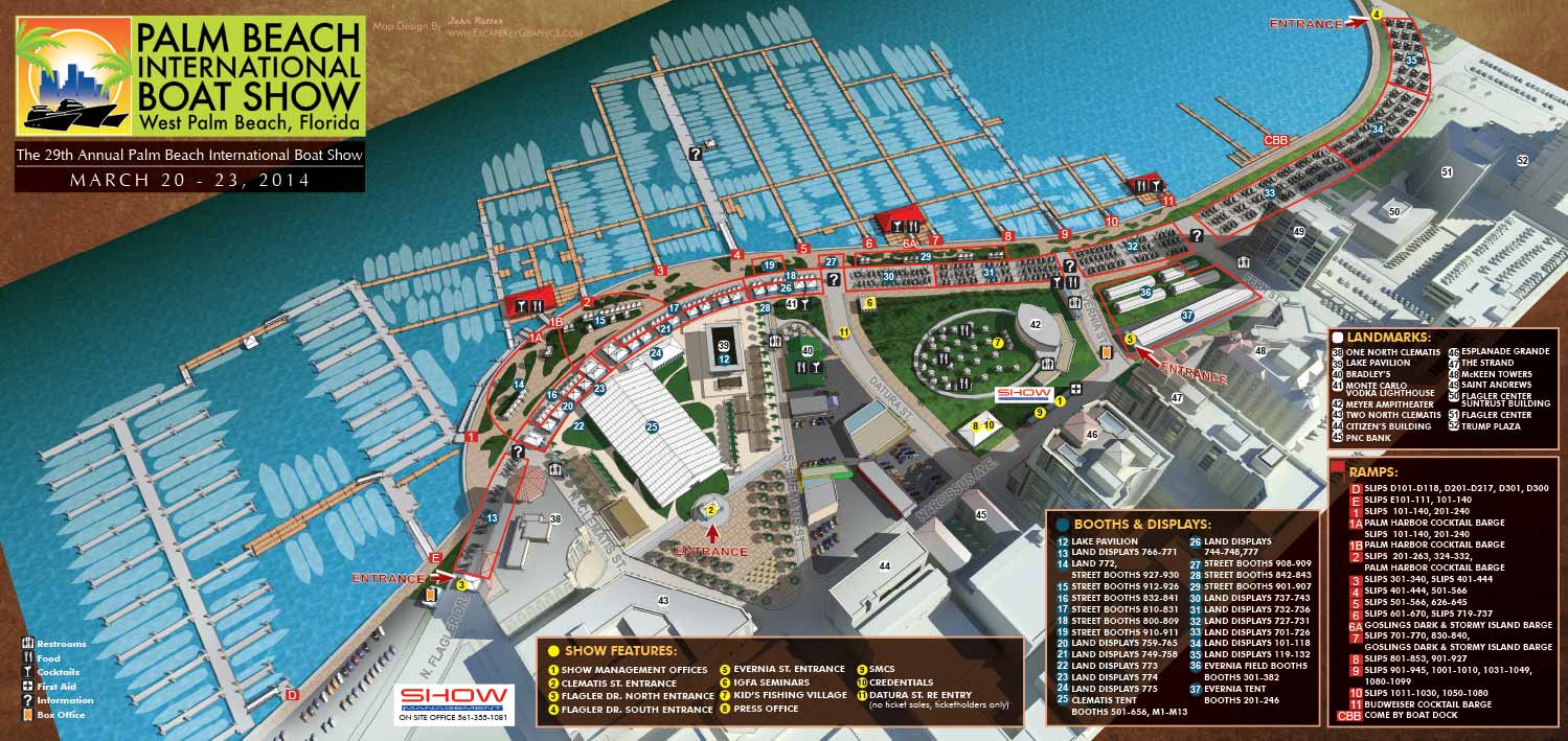
The 2014 map for the Palm Beach International Boat Show continued the technical foundation established the previous year, utilizing the same detailed digital three dimensional model. However, it introduced subtle artistic and strategic shifts that marked a transitional phase in the evolution of this annual project.
To present a fresh perspective, the scene was rendered from a slightly rotated vantage point, offering a new angle on the bustling waterfront layout. More notably, the time of day within the rendering was shifted to earlier in the evening. This adjustment created softer, more diffuse shadows compared to the previous year's sharper contrasts, resulting in a calmer overall visual tone.
This map also represents the beginning of a deliberate design philosophy to focus the viewer's attention. Elements lying outside the official show borders, such as surrounding buildings, were rendered in a muted, monochromatic style. This technique, a precursor to later methods, visually faded the background to make the vibrant, detailed show grounds the unambiguous focal point. During this period, key landmarks were still identified in the key, though this practice would later be streamlined.
For navigation, the map maintained the reliable wayfinding system that had proven effective. This consistency was crucial for returning visitors and exhibitors, providing instant familiarity. A clear color coded system was in place: red numbered markers identified essential infrastructure like dock ramps and exhibitor areas, while white and yellow markers highlighted major features and landmarks. This structured visual language successfully managed the complexity of the large scale event layout, guiding attendees with clarity.
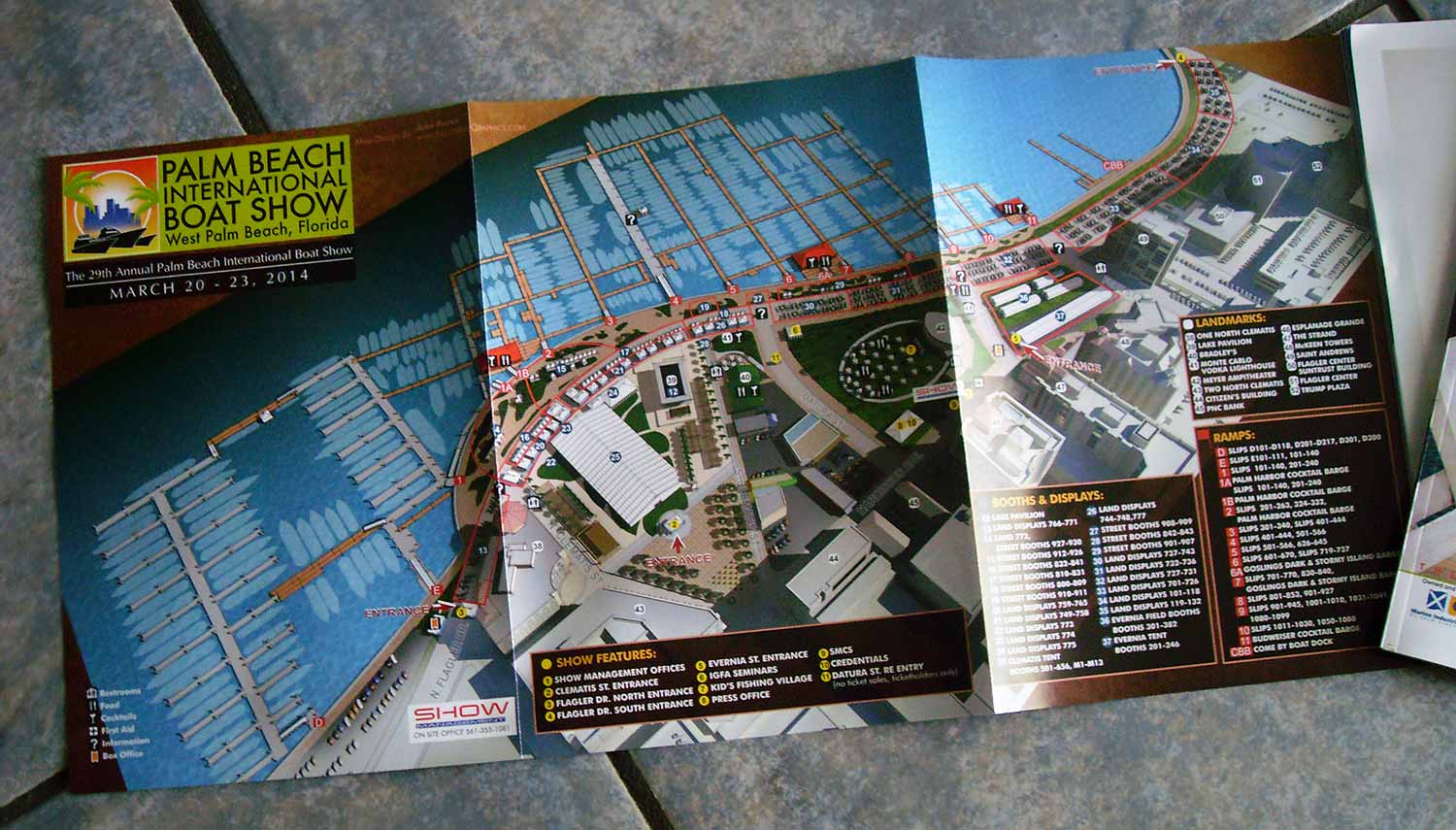
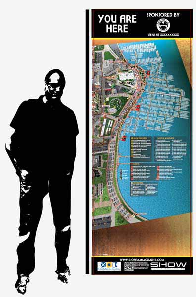
The map served multiple vital roles for the show. It functioned as a primary marketing image in the lead up to the event, a detailed printed handout for attendees, and a resource online. Additionally, a custom vertical version was created specifically for on site signage. This adaptation required a complete re-rendering of the 3D model from a new angle and a meticulous redesign of all keying and graphics to suit the tall format, demonstrating the flexibility of the core digital asset to meet diverse practical needs.
This illustrated map was featured in both the Palm Beach Daily News and The Palm Beach Post, underscoring its role as the official and definitive visual guide to the event for the local community.
Maps For Palm Beach International Boat Show:
- About The Palm Beach Boat Show
- Main Map: 2026 | 2025 | 2024 | 2023 | 2022 | 2021 | 2020 | 2019 | 2018 | 2017 | 2016 | 2015 | 2014 | 2013| 2012 | 2011
- Transit & Parking Map: 2026 | 2025 | 2024 | 2023 | 2022 | 2020 | 2019 | 2018 | 2016
- Program Layout: 2026 | 2025 | 2024
- Video: 2013
Palm Beach International Boat Show: A Premier Marine Event & Showcase for Custom Map Design:
The Palm Beach International Boat Show (PBIBS) is one of the most prestigious and influential boat shows in the United States, attracting marine enthusiasts, yacht buyers, industry professionals, and visitors from around the world each year. Held along Flagler Drive in downtown West Palm Beach, Florida, this waterfront event features an extraordinary display of luxury vessels, marine accessories, and lifestyle experiences - all set against the scenic backdrop of the Intracoastal Waterway.
Since its inception in 1982, PBIBS has grown into a major economic and cultural driver for the region, with attendance regularly surpassing 55,000 visitors and contributing more than $1 billion in economic impact to Palm Beach County.
World Class Yachts and Marine Innovation
Each year the show presents an impressive lineup of more than 800 to 1,000 boats and vessels, ranging from nimble 8 foot inflatable boats to luxurious superyachts approaching 300 feet in length. With over 600 exhibiting brands and hundreds of boats on display, PBIBS is a premier destination for exploring the latest in marine technology, yacht design, and nautical accessories.
The event also includes specialty showcases such as the Superyacht Show at Palm Harbor, educational seminars on boating and ownership, live activations like the AquaZone, and family-friendly activities including kids’ fishing clinics.
Relaxed Luxury & Local Culture
Unlike some of the larger boat shows in South Florida—such as Miami and Fort Lauderdale—the Palm Beach International Boat Show offers a somewhat more relaxed and refined atmosphere, with easy access to parking, public transit, and downtown amenities. Attendees often combine their day at the show with visits to nearby restaurants, bars, galleries, and shopping districts like CityPlace (now known as Rosemary Square), making it an attractive cultural and social destination for locals and visitors alike.
Art, Innovation & VIP Experiences
PBIBS is not just about boats - it’s also increasingly about lifestyle, luxury, and cultural engagement. VIP ticket holders enjoy access to premium lounges, gourmet dining, and exclusive events that sometimes coincide with related cultural offerings like the Palm Beach Modern + Contemporary (PBM+C) Art Fair, blending the worlds of fine art and luxury yachting.
For art lovers and design conscious attendees, the visual identity of the show is critical - not only in exhibits and signage but in how visitors navigate the expansive layout of boats, exhibits, food and beverage zones, and educational activations.
Featured Map Illustrator: John Potter / Escape Key Graphics
For more than a decade - from 2011 to the present - I have served as the illustrator and designer for the official Palm Beach International Boat Show map. Over the years, I have collaborated closely with the show’s production team at Informa Markets to refine and evolve the show’s visual mapping system to meet the needs of attendees, exhibitors, and staff as the event continues to grow and change.
My contributions have included:
-
Official show map illustration—updated annually to reflect layout changes and new technologies
-
App and digital maps used on mobile platforms during the event
-
Signage and wayfinding graphics throughout the show footprint
-
Transit and foldable maps designed for easy distribution and practical use
Each year’s map reflects improvements in style, software, and usability, ensuring that visitors have a seamless visual experience while navigating the show’s dynamic waterfront layout.
WAYFINDING MAPS:


WHAT ARE WAYFINDING MAPS:
Wayfinding maps are maps that help you figure out
- Where you are
- Where you want to be
- and how to get from one to the other
I know what you're thinking... Isn't that all maps? That was my first reaction as well, but this is not necessarily the case. Some maps only provide an overview of an area and some maps show topography or things like crime rates etc. These kinds of maps are becoming more popular with the advent of GIS, but that's another story.
My maps do tend to be geographical in nature and fit the description of wayfinding maps, but I go about it differently on different maps and I place emphasis on different methods. For instance... Some of my maps are overhead street map type maps while most are illustrated. The illustrated maps I create lean more on landmarks as a method of location while overhead maps require the user to think more abstractly and use signs or other markings in the real world to associate the map with reality. Some of my maps specify routes to be taken to reach destinations, some show paths, but leave the user to choose which they take and some simply show where things are in relation to one another giving more directional than specific guidance.
Some people refer to what they call digital wayfinding. This is usually loosely defined as wayfinding on a digital device like a phone or laptop with some form of interactivity involved. The zoomable maps I have on my site fall into this category but beyond that is software that chooses a route for you or describes facilities in your vicinity etc.
If you would like a quote for a wayfinding map please contact me.
PORTFOLIOS
- Illustration Portfolio: Start here for custom illustration and book covers. You can also browse illustrated maps and architectural rendering.
- Fine Art: I offer original paintings and drawings, including my Custom Halftone Series. You will also find mural work here.
- Graphic Design & Motion: View my graphic design portfolio. After that, explore motion design and animated illustrations.
- Maps by application: I create illustrated maps for boat shows, resorts, marinas, real estate, transportation, transit and parking, towns and cities, parks, and wayfinding.
- Additional project types: I also produce cover illustration, vehicle and vinyl wraps, proposal renderings, and street art.
- Illustration methods: My techniques include vector, isometric and axonometric, painting, black and white, GeoData maps, overhead maps, and custom halftones.
- Software portfolios: I work primarily in Adobe Photoshop, Adobe Illustrator, SketchUp Pro, and Adobe InDesign. For motion projects, I use Premiere Pro and After Effects.