Fort Lauderdale International Boat Show SYBAss Map 2025
Fort Lauderdale International Boat Show SYBAss Map 2025
A custom illustrated map for the SYBAss area at the Fort Lauderdale International Boat Show
For all the latest information on SYBAss please visit their site at SYBAss.org.
If you are interested in hiring me to create an original map or illustration for you please contact me.
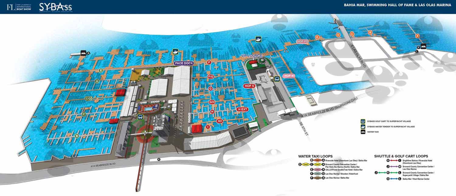
Basis of This Map
This map, like most of my boat show maps, is built on a digital three dimensional model. I created this particular model back in 2013. It covers this area of downtown Fort Lauderdale, including Bahia Mar, Swimming Hall of Fame, Las Olas Marina and the neighboring buildings and streets.
Each year I update the model with the new locations of floating docks and exhibitor spaces. I render it from the desired angle, then retouch and refine in Photoshop. Finally I add the logos, map key, and all other graphics in Adobe Illustrator.
About This Map
SYBAss, which stands for Superyacht Builders Association, wanted their own version of the main show map I created for Informa Markets. They asked for a slightly stripped down version focused specifically on their area.
Because I already had the updated three dimensional model, this was a straightforward request. Normally having a model to work from means I can change the angle, zoom level, or field of view to create a completely custom view. But this year the client was happy with the existing angle and layout. They just wanted their own version of the map.
I checked with Informa to make sure this was acceptable and they had no objections. So I produced a clean version of the map tailored to SYBAss needs.
Your Map
If you need a map for a boat show, an event, or any other venue that requires clear, detailed, and visually consistent navigation, contact me. I have done this work before and I would be glad to do it for you.

SYBAss Marinas Map

2025 FLIBS SYBAss Map

PBIBS SYBAss Map
Fort Lauderdale International Boat Show Maps:

Fort Lauderdale International Boat Show Map

Miami International Boat Show 2026

Newport Beach International Boat Show Map

Newport International Boat Show Map

San Diego International Boat Show Map

Sarasota Boat Show Map

Windy City Boat & Yacht Show Map

Boat Show Map

A South American Boat Show Map

Boat Show Illustrated Map

Chicago International Boat Show Map

St. Pete Boat Show Map

Convention Center Map

Transportation Map Using GeoData

Transportation & Parking Map

Illustrated Map of Marinas

Convention Center Map

Yacht Haven Grande Miami

Marina Map

Transit Map

Show Proposal Rendering

Yacht Club Map

Miami International Boat Show 2025

Transportation & Parking Map

Miami Beach Convention Center
PBIBS SYBAss Map
PORTFOLIOS
- Illustration Portfolio: Start here for custom illustration and book covers. You can also browse illustrated maps and architectural rendering.
- Fine Art: I offer original paintings and drawings, including my Custom Halftone Series. You will also find mural work here.
- Graphic Design & Motion: View my graphic design portfolio. After that, explore motion design and animated illustrations.
- Maps by application: I create illustrated maps for boat shows, resorts, marinas, real estate, transportation, transit and parking, towns and cities, parks, and wayfinding.
- Additional project types: I also produce cover illustration, vehicle and vinyl wraps, proposal renderings, and street art.
- Illustration methods: My techniques include vector, isometric and axonometric, painting, black and white, GeoData maps, overhead maps, and custom halftones.
- Software portfolios: I work primarily in Adobe Photoshop, Adobe Illustrator, SketchUp Pro, and Adobe InDesign. For motion projects, I use Premiere Pro and After Effects.