2024 Fort Lauderdale International Boat Show: Broward County Convention Center Map
Client: Informa Markets
Broward County Convention Center Map for the 2024 Fort Lauderdale International Boat Show. Visit their official site at FLIBS.com for information on the show and more up to date information.
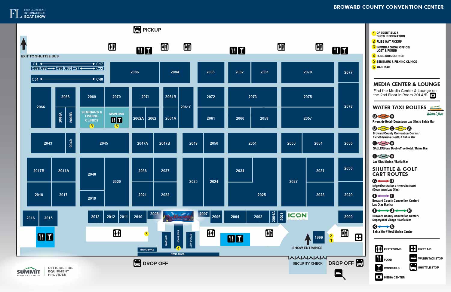
For the 2024 Fort Lauderdale International Boat Show, the Broward County Convention Center map was updated from the previous year's proven design. The primary practical revision involved updating the exhibitor spaces and their corresponding numbering to reflect the current year's floor plan. This ensured the map remained an accurate and reliable tool for attendees navigating the expansive hall.
The most notable visual evolution was the color palette. The exhibitor spaces, previously red, were updated to a more subdued dark blue. This intentional shift lends the overall composition a calmer, more relaxed aesthetic. The new color maintains a strong contrast against the light blue field of the convention center floor, ensuring all spaces remain distinctly visible and easy to identify, while contributing to a more refined and modern visual presentation.
Functional Design with an Integrated Map Legend
The map continues to employ a clear, overhead diagrammatic style, which is ideally suited to the convention center's open layout. This approach prioritizes functional clarity over architectural detail, allowing guests to focus on locating exhibitors by their assigned booth numbers with maximum efficiency.
All essential navigational information is consolidated into a single, well organized sidebar that serves as the comprehensive map legend. This unified reference area includes a system for key points of interest and a graphical representation of shuttle routes, maintaining the clean and uncluttered appearance that has proven effective in past years. This design ensures that the map can be quickly understood at a glance, whether viewed in a printed program, on digital signage, or within a mobile application.
This update demonstrates my commitment to refining successful designs with thoughtful adjustments that enhance both aesthetics and usability. By balancing visual appeal with straightforward functionality, I create maps that serve as indispensable tools for event navigation and planning.
For more examples of our strategic graphic design for major venues and events, please explore my Map Portfolio.
Fort Lauderdale International Boat Show Maps 2024:
Bahia Mar, Swimming Hall of Fame & Las Olas Marina Map | Transit and Parking Map | Marinas (17th St Cswy) Map | Broward County Convention Center Map | Program LayoutFort Lauderdale International Boat Show Maps:
- About Fort Lauderdale International Boat Show
- Bahia Mar, Swimming Hall of Fame & Las Olas Marina Maps: 2025 | 2024 | 2023 | 2022 | 2020 | 2019 | 2018 | 2017 | 2016 | 2015 | 2014 | 2013 | 2012 | 2011 | 2010
- Parking and Transportation Maps: 2025 | 2024 | 2023 | 2022 | 2020 | 2019 | 2018 | 2015 Bus | 2015 Water Taxi | 2014 | 2013 | 2012 | 2011
- Broward County Convention Center Maps: 2025 | 2024 | 2023 | 2022 | 2017 Sailfish Pavilion | 2017 | 2016 Sailfish Pavilion | 2016 | 2015 Sailfish Pavilion | 2015 | 2014 Sailfish Pavilion | 2014 | 2013 Sailfish Pavilion | 2013 | 2012 | 2011 | 2010
- Marinas Maps: 2025 | 2024 | 2023 | 2022 | 2019 | 2016
- Program Layouts: 2025 | 2024 | 2023 | 2022
- Signs: 2013 looking north | 2013 Yachting Tent
- Video: 2013 54th Annual
- Illustrations (not maps): 2014A | 2014B
Fort Lauderdale International Boat Show (FLIBS): World’s Largest Marine Event & Custom Map Design Showcase:
The Fort Lauderdale International Boat Show (FLIBS) is widely recognized as the largest in-water boat show in the world, held annually in Fort Lauderdale, Florida - often called the “Yachting Capital of the World.” Produced by Informa Markets and owned by the Marine Industries Association of South Florida (MIASF), FLIBS draws a global audience of yacht owners, buyers, industry professionals, and enthusiasts to South Florida each fall.
Spanning nearly 90 acres and more than three million square feet of exhibit space across multiple waterfront locations - including Bahia Mar Yachting Center, Las Olas Marina, Pier Sixty-Six, Hall of Fame Marina, Convention Center, and more. FLIBS features over 1,300 boats and hundreds of exhibitors from more than 50 countries.
A Global Marine Marketplace and Lifestyle Event
Each five-day show attracts more than 100,000 visitors, ranging from seasoned yacht buyers and marine professionals to aspiring boat owners and lifestyle attendees. Vessels on display span a remarkable range from sleek sport boats and performance center consoles to luxury superyachts and large world debuts making FLIBS the premier destination to experience the latest innovations in boating, marine technology, and luxury maritime living.
The 2025 show continued this legacy, showcasing a robust lineup of superyachts and high-end brokerage listings valued at nearly $2 billion, alongside new builds and debut models that underscore Fort Lauderdale’s significance in global yacht markets.
Beyond boats, the show offers immersive experiences including interactive exhibits, luxury lifestyle activations, VIP lounges, educational seminars, networking events, and opportunities to connect with top marine manufacturers, brokers, designers, and service providers.
Economic Impact and Industry Influence
FLIBS is not only a key showcase for product launches and industry trends, it’s also a powerful economic engine. Studies consistently highlight the event’s substantial impact on Florida’s economy, generating well over $1.7 billion in annual economic output, supporting tens of thousands of jobs, and driving significant tax revenue and tourism activity across the region.
Custom Map Illustration by John Potter / Escape Key Graphics
For many attendees, one of the most memorable elements of the Fort Lauderdale International Boat Show is the illustrated map system used throughout the event, helping visitors navigate the sprawling multi-location layout with confidence.
From 2010 through present (with the exception of 2021), I had the privilege of serving as the primary map illustrator and designer for FLIBS, working closely with Informa Markets (previously Show Management) to evolve the look, usability, and precision of the show’s cartographic and visual wayfinding materials. These maps have been used:
-
As the official printed show map, tailored each year to reflect expanded and redesigned show footprints
-
Within the FLIBS mobile app to help users navigate docks, tents, marinas, and exhibitor displays
-
On exhibit signage and environmental graphics throughout multiple show locations
-
As transit, guide, and foldable maps for attendee convenience
Over the years, I’ve adapted styles, software workflows, and presentation formats to improve clarity, navigability, and visual impact as the show has grown in size and complexity. My designs aim to balance technical accuracy with artistic clarity, making it easy for attendees to find exhibitors, boats, services, and key show features while reinforcing the premium brand experience of FLIBS.
Why This Matters to Marine, Luxury, and Event Clients
If you’ve enjoyed the Fort Lauderdale International Boat Show and seen these maps in action, whether printed, on signage, or in your FLIBS app, then you’ve witnessed how strategic map design and illustration can elevate a major event. Great visual wayfinding not only improves user experience but strengthens brand perception, supports marketing, and enhances audience engagement across large-scale environments.
Whether you’re planning a future show, a corporate event, or a branded experience that needs clear, compelling visual communication, custom illustration and thoughtful map design can make a meaningful difference. Visit EscapeKeyGraphics.com to explore portfolio examples and learn how custom illustration can support your next project.
CUSTOM BOAT SHOW MAPS:


PORTFOLIOS
- Illustration Portfolio: Start here for custom illustration and book covers. You can also browse illustrated maps and architectural rendering.
- Fine Art: I offer original paintings and drawings, including my Custom Halftone Series. You will also find mural work here.
- Graphic Design & Motion: View my graphic design portfolio. After that, explore motion design and animated illustrations.
- Maps by application: I create illustrated maps for boat shows, resorts, marinas, real estate, transportation, transit and parking, towns and cities, parks, and wayfinding.
- Additional project types: I also produce cover illustration, vehicle and vinyl wraps, proposal renderings, and street art.
- Illustration methods: My techniques include vector, isometric and axonometric, painting, black and white, GeoData maps, overhead maps, and custom halftones.
- Software portfolios: I work primarily in Adobe Photoshop, Adobe Illustrator, SketchUp Pro, and Adobe InDesign. For motion projects, I use Premiere Pro and After Effects. You can watch my demo reel here.