Illustrated Map of the Miami Yacht Show
Client: Informa Markets
 Z Card from FLIBS 2020 as an example
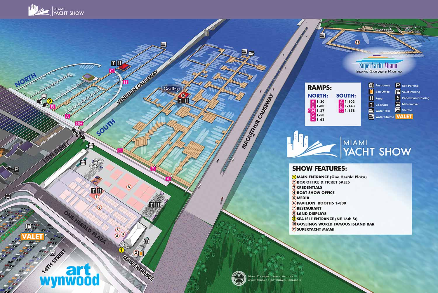
This illustrated map was created for the 2020 Miami International Boat Show and represents a refined continuation of the event’s visual language. Developed from a detailed digital three dimensional model, the map centers on the primary show locations at Venetian Marina and One Herald Plaza while also providing clear orientation to the Superyacht Miami Show on Watson Island, widely known as Yacht Haven Grande. Presenting these venues together helps visitors quickly understand how the different parts of the show connect across Miami’s waterfront. Docks and access ramps are labeled directly on the map, show features are marked with numbered yellow indicators, and essential amenities are identified using clear, consistent icons. Streets and sponsor placements are integrated seamlessly into the illustration, while shuttle routes, Water Taxi service, and VIP tender access are communicated through a straightforward visual system.
The map was produced as part of a coordinated set of five maps included in the official show program, with page layout also completed by me. It was adapted for use across digital platforms, on site signage, and promotional materials. For an event of this scale, an effective wayfinding map is essential. In addition to helping guests move confidently through the show, it conveys a high level of organization and professionalism that supports the overall quality and reputation of the event.
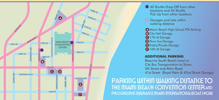
The 2020 Miami International Boat Show map of Venetian Marina and One Herald Plaza as well as a detail of the pavilion on site, transportation map and Superyacht Miami map were included on a large folding map printed by Z-CARD.
 Front of Z Card
 Back of Z Card
EXAMPLES OF MAPS CREATED FOR MIAMI BOAT SHOWS:


Maps For Boat Shows In Miami:
- About Miami Boat Shows
- Miami International Boat Show / Miami Yacht Show / Yachts Miami Beach / Miami Beach Yacht and Brokerage Show - Show Center/Primary Venue Maps: 2026 | 2025 | 2024 | 2023 | 2022 | 2020 | 2019 | 2018 | 2017 | 2016 | 2015 | 2014 | 2013 | 2012 | 2011
- Transportation Map: 2026 | 2025 | 2024 | 2023 | 2022 | 2020 | 2019 | 2016 | 2013 | 2012
- Program Layout: 2026 | 2025 | 2024 | 2023 | 2022
- Yacht Haven Grande at Island Gardens: 2026 | 2022 | 2020 | 2016
- Miami Beach Convention Center: 2026 | 2025 | 2024 | 2023 | 2022 | 2013 | 2012
- Sea Isle Marina Only: 2013 | 2012
- Miamarina at Bayside Only: 2013 | 2012 | 2011
- Bayfront Park: 2015
- Museum Park Marina: 2025 | 2024 | 2023 | 2022
- Illustration (not a map): 2014
- Video: 2013
Miami International Boat Show Maps 2013:
Miami Beach Convention Center Map | New Yacht & Power Boat Show at Sea Isle MarinaStrictly Sail Miami at Miamarina Bayside | Miami International Boat Show Transit | Miami Beach Convention Center Parking


PORTFOLIOS
- Illustration Portfolio: Start here for custom illustration and book covers. You can also browse illustrated maps and architectural rendering.
- Fine Art: I offer original paintings and drawings, including my Custom Halftone Series. You will also find mural work here.
- Graphic Design & Motion: View my graphic design portfolio. After that, explore motion design and animated illustrations.
- Maps by application: I create illustrated maps for boat shows, resorts, marinas, real estate, transportation, transit and parking, towns and cities, parks, and wayfinding.
- Additional project types: I also produce cover illustration, vehicle and vinyl wraps, proposal renderings, and street art.
- Illustration methods: My techniques include vector, isometric and axonometric, painting, black and white, GeoData maps, overhead maps, and custom halftones.
- Software portfolios: I work primarily in Adobe Photoshop, Adobe Illustrator, SketchUp Pro, and Adobe InDesign. For motion projects, I use Premiere Pro and After Effects.