FLIBS Convention Center 2014 Exterior Map: The Sailfish Pavilion
Client: Show Management
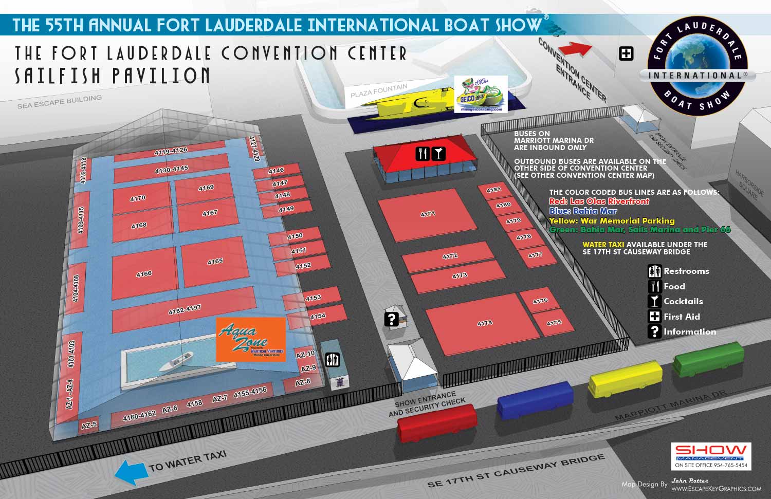
Broward County Convention Center Visitor's Map for the Fort Lauderdale International Boat Show
This illustration presents the 2014 exterior map of the Sailfish Pavilion for the Fort Lauderdale International Boat Show. As the dedicated outdoor exhibit area adjacent to the Broward County Convention Center, this map serves as an essential companion to the main interior guide, providing a cohesive navigational experience for attendees moving between indoor and outdoor spaces.
Produced as part of the annual update cycle, this edition incorporated the necessary revisions to reflect the current year's show layout. The placement of exhibitors within the light rust colored footprints was adjusted, corresponding booth numbers were updated, and the keying for amenities and points of interest was refined. Additionally, featured sponsor logos were reviewed and updated to align with the event's current partnerships.
The design maintains strong continuity with the established visual system. Rendered from the same comprehensive 3D digital model, it ensures spatial accuracy with the interior convention center map. The illustrative style remains consistent, utilizing transparent "ghosted" tents to reveal interior exhibitor layouts and retaining the familiar color coded shuttle buses and graphical icons. This approach provides returning visitors with immediate recognition while accurately detailing the specifics of the 2014 show.
This exterior map is a direct companion to the interior view. To see the detailed illustration of the convention center interior it connects to, please visit the Fort Lauderdale Convention Center 2014 Map.
For more examples of coordinated event cartography and environmental graphics, please explore my full Map Portfolio.
Fort Lauderdale International Boat Show Maps:
- About Fort Lauderdale International Boat Show
- Bahia Mar, Swimming Hall of Fame & Las Olas Marina Maps: 2025 | 2024 | 2023 | 2022 | 2020 | 2019 | 2018 | 2017 | 2016 | 2015 | 2014 | 2013 | 2012 | 2011 | 2010
- Parking and Transportation Maps: 2025 | 2024 | 2023 | 2022 | 2020 | 2019 | 2018 | 2015 Bus | 2015 Water Taxi | 2014 | 2013 | 2012 | 2011
- Broward County Convention Center Maps: 2025 | 2024 | 2023 | 2022 | 2017 Sailfish Pavilion | 2017 | 2016 Sailfish Pavilion | 2016 | 2015 Sailfish Pavilion | 2015 | 2014 Sailfish Pavilion | 2014 | 2013 Sailfish Pavilion | 2013 | 2012 | 2011 | 2010
- Marinas Maps: 2025 | 2024 | 2023 | 2022 | 2019 | 2016
- Program Layouts: 2025 | 2024 | 2023 | 2022
- Signs: 2013 looking north | 2013 Yachting Tent
- Video: 2013 54th Annual
- Illustrations (not maps): 2014A | 2014B
BOAT SHOW MAPS ARTICLE - SOUTHERN BOATING MAGAZINE 2016:
"Navigating Miami’s multiple venues is easier when you use a map. If you’re at Yachts Miami Beach – formerly The Miami Yacht and Brokerage Show – the man behind those maps is John Potter of Escape Key Graphics, who created his first boat show map for the 201 Fort Lauderdale Int’l. Boat Show. It wasn't long before the creative concept spread. Less intimidating than site plans and more easier to follow than an aerial photography, Potter’s maps now grace the Stuart Boat Show, St. Petersburg Power & Sailboat Show in Florida and International Boat Shows like Newport, Palm Beach and Panama. His work on these shows frequently extends to many maps such as detailed area maps and transit maps. Potter’s maps can also be seen beyond the yachting industry in theme parks, resorts, wildlife sanctuaries, municipalities, campuses and gardens including Flamingo Gardens, Dinosaur World parks or The Dover International Speedway."
ADDENDUM:
I am presently responsible for illustrated maps for The Chicago International Boat Show, The Fort Lauderdale International Boat Show, The Miami International Boat Show, The Newport International Boat Show, The Newport Beach International Boat Show, The San Diego International Boat Show, The Windy City Boat & Yacht Show, The Palm Beach International Boat Show, The Suncoast Boat Show and the The Saint Petersburg Power and Sailboat Show.
There is a directory in my Boat Show Map Portfolio
CUSTOM BOAT SHOW MAPS:


PORTFOLIOS
- Illustration Portfolio: Start here for custom illustration and book covers. You can also browse illustrated maps and architectural rendering.
- Fine Art: I offer original paintings and drawings, including my Custom Halftone Series. You will also find mural work here.
- Graphic Design & Motion: View my graphic design portfolio. After that, explore motion design and animated illustrations.
- Maps by application: I create illustrated maps for boat shows, resorts, marinas, real estate, transportation, transit and parking, towns and cities, parks, and wayfinding.
- Additional project types: I also produce cover illustration, vehicle and vinyl wraps, proposal renderings, and street art.
- Illustration methods: My techniques include vector, isometric and axonometric, painting, black and white, GeoData maps, overhead maps, and custom halftones.
- Software portfolios: I work primarily in Adobe Photoshop, Adobe Illustrator, SketchUp Pro, and Adobe InDesign. For motion projects, I use Premiere Pro and After Effects. You can watch my demo reel here.