2014 Fort Lauderdale International Boat Show Map: A Thematic Evolution
Client: Show Management
For information about the Fort Lauderdale International Boat Show visit FLIBS.com
Client: Burgess Yachts
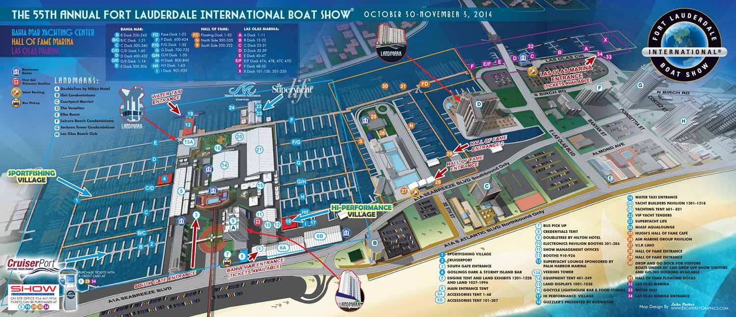
The 2014 Fort Lauderdale International Boat Show (FLIBS) map introduced distinct thematic elements while building upon the technical foundation established the previous year. This edition reflects a thoughtful blend of artistic influence and practical refinements to enhance both its aesthetic appeal and navigational utility.
A key design inspiration for this year came from the visual language of Prewar Italian Futurism. This influence is most evident in the dynamic treatment of the map's negative spaces, where geometric forms and a sense of streamlined motion subtly echo the movement and energy of the avant garde movement. Beyond style, we also enhanced the map's function as a wayfinding tool by integrating illustrated landmarks. Prominent local structures were rendered as spot illustrations with clear directional arrows, helping attendees orient themselves within the expansive show grounds using recognizable visual cues.
The core navigation system remained consistent for user familiarity, but a significant interface improvement was made to the exhibitor menu. It was placed within a more defined, distinguishable box, a design decision that would prove prescient for future interactive applications. These artistic and functional updates were applied to the comprehensive digital 3D model created in 2013. The majority of the production work therefore involved efficiently updating the layout, including repositioning floating docks, adjusting on land tent locations, and refreshing all informational menus to reflect the current year's exhibitors.
A Versatile Illustrative System
The final 2014 map served as a central asset across multiple platforms. It was featured on the official show website for marketing, produced as a printed handout for attendee wayfinding, and adapted into a vertical format for signage throughout the event and appeared in the phone app. It also appeared in Boats International Magazine as promotional material.
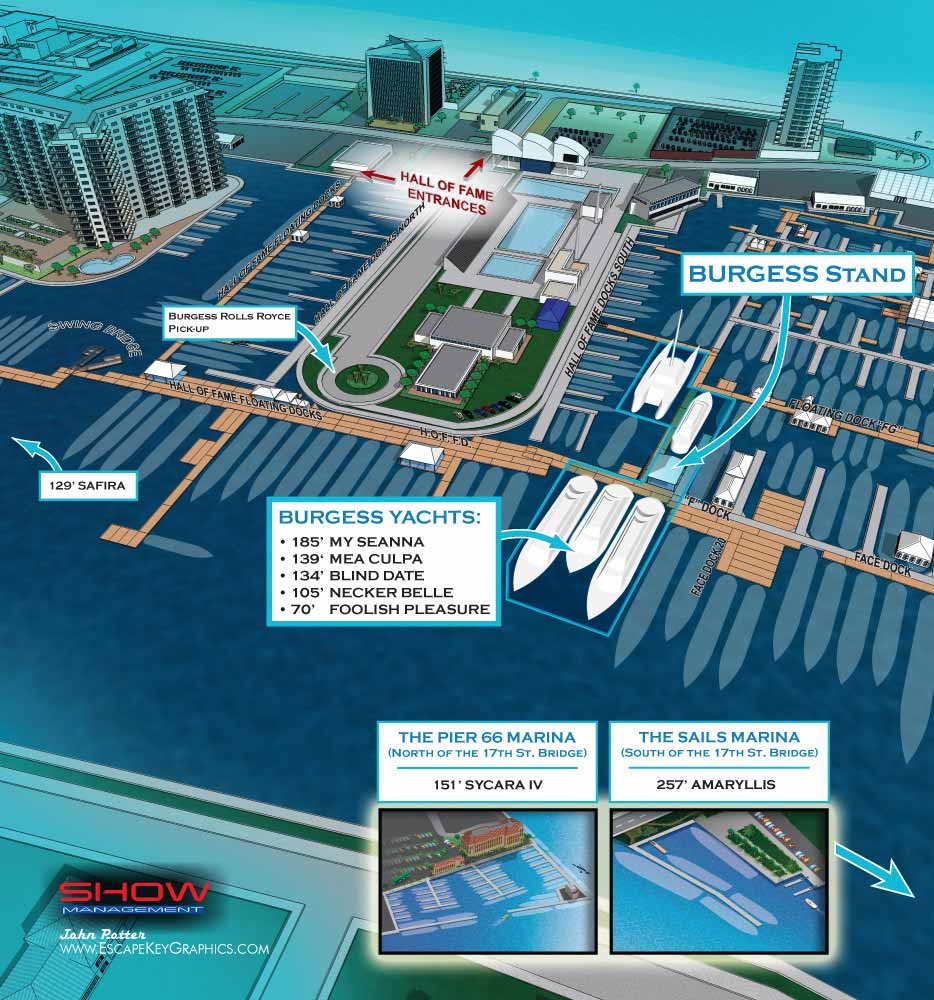
The scope of work for the 2014 show extended well beyond the main map. The project also included two standalone marketing illustrations, as well as a suite of supplementary maps: The Broward County Convention Center, a dedicated Transportation Map, and individual maps for The Pier 66 Marina, The Sails Marina, and The Hilton Marina. Additionally, six specialized sign maps were created to ensure cohesive navigation across every part of the show.
This project demonstrates how a mature digital model allows for efficient annual updates while providing the creative flexibility to introduce new thematic layers and functional improvements, resulting in a versatile and cohesive visual system for a world class event.
This map is part of an ongoing series. To view the progression of this work, please see the maps from 2013 FLIBS and previous years.
For more examples of detailed event cartography and environmental graphics, please explore my full Map Portfolio.
Fort Lauderdale International Boat Show Maps:
- About Fort Lauderdale International Boat Show
- Bahia Mar, Swimming Hall of Fame & Las Olas Marina Maps: 2025 | 2024 | 2023 | 2022 | 2020 | 2019 | 2018 | 2017 | 2016 | 2015 | 2014 | 2013 | 2012 | 2011 | 2010
- Parking and Transportation Maps: 2025 | 2024 | 2023 | 2022 | 2020 | 2019 | 2018 | 2015 Bus | 2015 Water Taxi | 2014 | 2013 | 2012 | 2011
- Broward County Convention Center Maps: 2025 | 2024 | 2023 | 2022 | 2017 Sailfish Pavilion | 2017 | 2016 Sailfish Pavilion | 2016 | 2015 Sailfish Pavilion | 2015 | 2014 Sailfish Pavilion | 2014 | 2013 Sailfish Pavilion | 2013 | 2012 | 2011 | 2010
- Marinas Maps: 2025 | 2024 | 2023 | 2022 | 2019 | 2016
- Program Layouts: 2025 | 2024 | 2023 | 2022
- Signs: 2013 looking north | 2013 Yachting Tent
- Video: 2013 54th Annual
- Illustrations (not maps): 2014A | 2014B
Fort Lauderdale International Boat Show Map Video
2013 54th Annual
CUSTOM BOAT SHOW MAPS:


BOAT SHOW MAPS ARTICLE - SOUTHERN BOATING MAGAZINE 2016:
"Navigating Miami’s multiple venues is easier when you use a map. If you’re at Yachts Miami Beach – formerly The Miami Yacht and Brokerage Show – the man behind those maps is John Potter of Escape Key Graphics, who created his first boat show map for the 201 Fort Lauderdale Int’l. Boat Show. It wasn't long before the creative concept spread. Less intimidating than site plans and more easier to follow than an aerial photography, Potter’s maps now grace the Stuart Boat Show, St. Petersburg Power & Sailboat Show in Florida and International Boat Shows like Newport, Palm Beach and Panama. His work on these shows frequently extends to many maps such as detailed area maps and transit maps. Potter’s maps can also be seen beyond the yachting industry in theme parks, resorts, wildlife sanctuaries, municipalities, campuses and gardens including Flamingo Gardens, Dinosaur World parks or The Dover International Speedway."
ADDENDUM:
I am presently responsible for illustrated maps for The Chicago International Boat Show, The Fort Lauderdale International Boat Show, The Miami International Boat Show, The Newport International Boat Show, The Newport Beach International Boat Show, The San Diego International Boat Show, The Windy City Boat & Yacht Show, The Palm Beach International Boat Show, The Suncoast Boat Show and the The Saint Petersburg Power and Sailboat Show.
There is a directory in my Boat Show Map Portfolio
PORTFOLIOS
- Illustration Portfolio: Start here for custom illustration and book covers. You can also browse illustrated maps and architectural rendering.
- Fine Art: I offer original paintings and drawings, including my Custom Halftone Series. You will also find mural work here.
- Graphic Design & Motion: View my graphic design portfolio. After that, explore motion design and animated illustrations.
- Maps by application: I create illustrated maps for boat shows, resorts, marinas, real estate, transportation, transit and parking, towns and cities, parks, and wayfinding.
- Additional project types: I also produce cover illustration, vehicle and vinyl wraps, proposal renderings, and street art.
- Illustration methods: My techniques include vector, isometric and axonometric, painting, black and white, GeoData maps, overhead maps, and custom halftones.
- Software portfolios: I work primarily in Adobe Photoshop, Adobe Illustrator, SketchUp Pro, and Adobe InDesign. For motion projects, I use Premiere Pro and After Effects. You can watch my demo reel here.